Skip to content

Gambling, Culture, Living, Traveling, Food, all things Vietnam and South East Asia

Top Sportsbooks

9.9

Bovada

75% Cash Bonus
Read Review
9.8

BetOnline

100% Free Play
Read Review
9.6

Heritage Sports

100% Free Play Bonus
Read Review
9.6

BetAnySports

30% Cash Bonus
Read Review
9.5

Everygame

100% Cash Bonus
Read Review
9.5

Bookmaker

25% Cash Bonus
Read Review

flyingillini

flyingillini

Joined
Jul 25, 2022
Messages
16,086
There you go!!!!!!!!!! The big Durian! Also, why the Durian, Fly? Is this their national fruit?
The National fruit of Cambodia is the Chicken egg banana. The banana is regarded as the national fruit of Cambodia among the most other valuable plants and provides many benefits to society same as a palm tree and Rumduol flower.
 

BMR Genie

BMR Genie

Joined
Jun 16, 2016
Messages
30,340
The National fruit of Cambodia is the Chicken egg banana. The banana is regarded as the national fruit of Cambodia among the most other valuable plants and provides many benefits to society same as a palm tree and Rumduol flower.
Oh wow! One of my top fav types of banana. The funny thing is I just ate 2 pcs this morning. :love:

Good to know this, Fly. But why there is a big Durian fruit there?
 

flyingillini

flyingillini

Joined
Jul 25, 2022
Messages
16,086
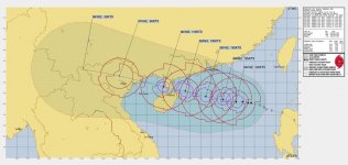
IMG_0670.jpegIMG_0671.jpeg
Typhoon 🌀 Yagi is on the way

Thursday, September 5, 2024:

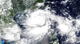
Typhoon Yagi is currently a Category 4 storm with winds over 200 km/hour in the eyewall. It looks like it will intensify more and probably become a Category 5 storm today or tomorrow. It is located East of Hainan and will cross the Chinese peninsula late on Friday. It's a very powerful storm and the eye is becoming well pronounced.

We may start feeling effects soon as there are some offshoots from this system spinning off in multiple directions. Do not mistake these for the real storm, which will make landfall in Quang Ninh on Saturday. I can give you a better estimate tomorrow, but my advice right now is to go home early on Friday and then 'batten the hatches' as they say.

In Hanoi, although it will be much weaker, you should prepare for heavy rain and wind starting with gentle winds late Friday and then intensifying winds as the storm creeps closer - lasting about 24 hours, then followed by at least a few more days of rain. Stay home Saturday and Sunday. Don't risk Saturday night out. Better safe than sorry.

Winds could still be around 75-100 km/hour in Hanoi, meaning trees will be uprooted, debris will fly, buildings will be damaged. The Vietnamese government has mobilised thousands of troops for a Level 4 Natural Disaster Response along the coastline. Evacuation orders are coming. Please follow local advice and tour operators for more specific information.

Hanoi could receive some urban flooding damage, due to the intensity and prolonged heavy rain.

Hanoi is not used to strong winds - stay off the streets because of the danger of uprooted trees, flying debris and broken branches, etc.

This is a large typhoon, with the potential to disrupt and displace a lot of people. Please consider the vulnerable communities that will be affected soon.

Today - very hot and 'the calm before...' (37), with potential of a thunderstorm offshoot from the main storm.
Friday - still very hot (36) with cooler winds approaching later in the afternoon and evening.
Saturday - Heavy rain and WIND, starting in morning gradually and then intensifying throughout the day
Sunday - Steady rain, wind tapering off, much cooler temps

This forecast is not 'exact', and trajectories do change, typhoons accelerate and slow down as well. Just be mindful that it is coming.
 

Tanko

Tanko

Joined
Oct 27, 2021
Messages
42,596
View attachment 41744View attachment 41745
Typhoon 🌀 Yagi is on the way

Thursday, September 5, 2024:

Typhoon Yagi is currently a Category 4 storm with winds over 200 km/hour in the eyewall. It looks like it will intensify more and probably become a Category 5 storm today or tomorrow. It is located East of Hainan and will cross the Chinese peninsula late on Friday. It's a very powerful storm and the eye is becoming well pronounced.

We may start feeling effects soon as there are some offshoots from this system spinning off in multiple directions. Do not mistake these for the real storm, which will make landfall in Quang Ninh on Saturday. I can give you a better estimate tomorrow, but my advice right now is to go home early on Friday and then 'batten the hatches' as they say.

In Hanoi, although it will be much weaker, you should prepare for heavy rain and wind starting with gentle winds late Friday and then intensifying winds as the storm creeps closer - lasting about 24 hours, then followed by at least a few more days of rain. Stay home Saturday and Sunday. Don't risk Saturday night out. Better safe than sorry.

Winds could still be around 75-100 km/hour in Hanoi, meaning trees will be uprooted, debris will fly, buildings will be damaged. The Vietnamese government has mobilised thousands of troops for a Level 4 Natural Disaster Response along the coastline. Evacuation orders are coming. Please follow local advice and tour operators for more specific information.

Hanoi could receive some urban flooding damage, due to the intensity and prolonged heavy rain.

Hanoi is not used to strong winds - stay off the streets because of the danger of uprooted trees, flying debris and broken branches, etc.

This is a large typhoon, with the potential to disrupt and displace a lot of people. Please consider the vulnerable communities that will be affected soon.

Today - very hot and 'the calm before...' (37), with potential of a thunderstorm offshoot from the main storm.
Friday - still very hot (36) with cooler winds approaching later in the afternoon and evening.
Saturday - Heavy rain and WIND, starting in morning gradually and then intensifying throughout the day
Sunday - Steady rain, wind tapering off, much cooler temps

This forecast is not 'exact', and trajectories do change, typhoons accelerate and slow down as well. Just be mindful that it is coming.
You headed home now Fly?
 

BigJay

BigJay

Joined
Oct 28, 2021
Messages
12,224
View attachment 41744View attachment 41745
Typhoon 🌀 Yagi is on the way

Thursday, September 5, 2024:

Typhoon Yagi is currently a Category 4 storm with winds over 200 km/hour in the eyewall. It looks like it will intensify more and probably become a Category 5 storm today or tomorrow. It is located East of Hainan and will cross the Chinese peninsula late on Friday. It's a very powerful storm and the eye is becoming well pronounced.

We may start feeling effects soon as there are some offshoots from this system spinning off in multiple directions. Do not mistake these for the real storm, which will make landfall in Quang Ninh on Saturday. I can give you a better estimate tomorrow, but my advice right now is to go home early on Friday and then 'batten the hatches' as they say.

In Hanoi, although it will be much weaker, you should prepare for heavy rain and wind starting with gentle winds late Friday and then intensifying winds as the storm creeps closer - lasting about 24 hours, then followed by at least a few more days of rain. Stay home Saturday and Sunday. Don't risk Saturday night out. Better safe than sorry.

Winds could still be around 75-100 km/hour in Hanoi, meaning trees will be uprooted, debris will fly, buildings will be damaged. The Vietnamese government has mobilised thousands of troops for a Level 4 Natural Disaster Response along the coastline. Evacuation orders are coming. Please follow local advice and tour operators for more specific information.

Hanoi could receive some urban flooding damage, due to the intensity and prolonged heavy rain.

Hanoi is not used to strong winds - stay off the streets because of the danger of uprooted trees, flying debris and broken branches, etc.

This is a large typhoon, with the potential to disrupt and displace a lot of people. Please consider the vulnerable communities that will be affected soon.

Today - very hot and 'the calm before...' (37), with potential of a thunderstorm offshoot from the main storm.
Friday - still very hot (36) with cooler winds approaching later in the afternoon and evening.
Saturday - Heavy rain and WIND, starting in morning gradually and then intensifying throughout the day
Sunday - Steady rain, wind tapering off, much cooler temps

This forecast is not 'exact', and trajectories do change, typhoons accelerate and slow down as well. Just be mindful that it is coming.
1725552146370.jpeg
 

BMR Genie

BMR Genie

Joined
Jun 16, 2016
Messages
30,340
Top